Throughout the history of architecture in Iran, what has gained the attention of many researchers and experts is the full and intelligent compatibility of buildings and living spaces with their environment and location. Architects, using valuable knowledge and experience obtained from previous generations, have suggested specific architectures for humans living in any of Iranian climates and geographical locations in order to provide the highest possible level of comfort and the best access to a suitable living environment.
This can be categorized as part of the specific aspects of Iranian architecture. This architecture includes a general aspect that unites entire Iran together like a vast blanket. This general aspect is the comprehensive thinking which defines Iranian people in its geographical location. The beauty and art of Iranian architecture is the fact that this general aspect has been mixed with specific aspects of each location, achieving the best possible results.
The country of Iran, due to its vast land, includes various different environments and climates which affect and are affected by the geographical aspects of each region. Large fields of sand in the deserts, fertile river planes, thick and rainy forests, snowy mountains, and vast beaches are among the sights found in Iran.The Harmony of Architecture with Nature
Throughout the history of architecture in Iran, what has gained the attention of many researchers and experts is the full and intelligent compatibility of buildings and living spaces with their environment and location. Iranian architects have, over centuries, utilized inherited knowledge and experience to design spaces perfectly adapted to every climate zone in Iran, maximizing comfort and environmental harmony.
General and Specific Aspects of Iranian Architecture
Iranian architecture is characterized by two main aspects:
- The general aspect: a unifying architectural vision that connects all parts of Iran and reflects the Iranian people’s deep relationship with their environment.
- The specific aspect: a localized adaptation that responds to the unique climatic and geographical needs of each region.
The Diverse Geography of Iran
Iran is a vast land of contrasting environments, including:
- Sandy deserts
- Fertile plains
- Lush rainforests
- Snowy mountains
- Long coastlines
This diversity greatly impacts architectural strategies.
Geographic Regions and Their Architectural Impacts
Southern Iran: Warm and Humid Coasts
Iran’s southern border is lined by the Persian Gulf and the Sea of Oman, which link the country to international waters. The region is typically hot, with low rainfall and high humidity. To the west lies the fertile Khuzestan plains, and to the east, the arid lands of Sistan.
Northern Iran: The Caspian Coast and Alborz Mountains
To the north, the Caspian Sea, the world’s largest enclosed inland body of water, shapes the geography.
South of the sea lies the Alborz Mountain Range, trapping humidity between the mountains and sea. This results in a temperate and humid climate with:
- High rainfall
- Dense forests
- Fertile plains and roaring rivers
This region resembles European climates and is one of the most vibrant ecological zones in Iran.
Alborz Mountains: Natural Divider
The Alborz Mountains:
- Create a barrier between the humid north and the arid central plateau
- Are covered in snow during the wet seasons
- Feed seasonal and permanent rivers that shape northern and southern ecosystems
The Zagros Mountain Range
A Backbone of Iranian Geography
Stretching diagonally from the northwest to the south, the Zagros Mountains:
- Cover a large portion of Iran
- Gradually decrease in height toward the south
- Offer a cold and semi-humid climate in the west
- Have hosted many ethnic groups like the Kurds, Lurs, Bakhtiaris, and Azeris
Climate Impact and Water Resource Creation
The mountains affect:
- Climate: blocking humid western winds and creating arid central regions
- Water basins: feeding major rivers and lakes like Lake Urmia, Choghakhor Lagoon, and Gandoman Pond
A Vital Source of Water
For example, Chaharmahal and Bakhtiari Province, while occupying only 1% of Iran’s land, provides 10% of its freshwater, sourcing major rivers:
Karun River
- Originates in Bakhtiari mountains
- Flows to the Persian Gulf
- Enriches the Khuzestan plain, cradle of ancient civilizations
- Supports agriculture, communication, and trade
Zayandeh Roud
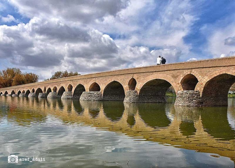
- Flows west to east
- Ends in the Gavkhouni basin near Isfahan
- Connects cities and villages and supports the growth of Isfahan, a historic capital of Iran
- Demonstrates the deep bond between architecture, water, and nature
Central Iran: Deserts and Sustainable Design
Natural Boundaries
The Alborz and Zagros ranges frame the flat central plains of Iran, which are:
- Arid to semi-arid
- Home to cities and villages near mountain foothills, rivers, or qanats
Sustainable Water Management
Due to low rainfall, ancient Iranians developed smart systems to:
- Harvest and store water
- Sustain agriculture and urban life
- Build Persian gardens, symbolic of paradise in Iranian culture
The Vast Iranian Desert
The central and eastern parts of Iran are dominated by:
- Low-altitude deserts
- Mountain ranges and wilderness with desert vegetation
These landscapes define much of Iran’s geographic and architectural character.


